

When we think about hiking, having the right tools can make all the difference.
One essential element is a topographic map.
These maps provide detailed information about the terrain, including elevation changes, trails, and landmarks, which are vital for planning our routes and ensuring a safe and enjoyable experience in the great outdoors.
Unlike standard maps, topographic maps give us a three-dimensional view of the landscape, helping us visualize the path ahead and anticipate potential challenges.
Choosing the best topographic map for our hiking needs involves considering a few key factors.
We should look for accuracy, durability, and ease of use.
Maps made from weather-resistant materials are important, especially if we encounter rain or rough conditions.
Additionally, the level of detail is crucial—some maps include intricate features like individual trails, while others may only show major landmarks.
Understanding these elements will help us select the right map for our next adventure.
As we explore the different options available, we’ll highlight some of the best topographic maps to enhance our hiking experience.
Each option has unique strengths, making it easier for us to find the perfect fit for our specific needs.
Best Topographic Maps for Hiking
When it comes to finding the perfect topographic maps for our hiking adventures, we want reliable options that guide us through the great outdoors.
We’ve compiled a list of the best maps available, tailored to enhance our hiking experiences.
Whether we’re planning a day trip or a longer journey, these maps will help us navigate with confidence.
Rocky Mountain Adventure Map
This map is a solid choice for anyone looking to explore the trails of Rocky Mountain National Park.
- Waterproof and tear-resistant for added durability
- Compact size fits perfectly in our pockets
- Provides GPS coordinates for easy navigation
- Limited to a specific geographic area
- Folded map may require care to prevent creasing
- May not include every single trail detail
When we think about navigating the beautiful trails of Rocky Mountain National Park, this topographic map by Outdoor Trail Maps stands out.
Its waterproof and tear-resistant material makes it ideal for the unpredictable weather typical of Colorado.
The compact size of the map, measuring just 4″x7″, allows us to carry it easily without sacrificing detail.
It effectively covers key areas like Longs Peak and Glacier Gorge while also mapping out the more secluded trails.
With updated trail routings ensuring accuracy, we can confidently tackle our hiking adventures.
Additionally, the inclusion of GPS coordinates for trailheads and junctions is invaluable, especially for those of us using devices for navigation.
Whether we are veterans or newcomers, having a reliable map adds a layer of safety and enjoyment to our hiking experience.
Overall, the Rocky Mountain Adventure Map is a great companion for discovering the varying landscapes of one of America’s most celebrated national parks.
Outdoor Trail Maps – Maroon Bells-Snowmass Wilderness Map
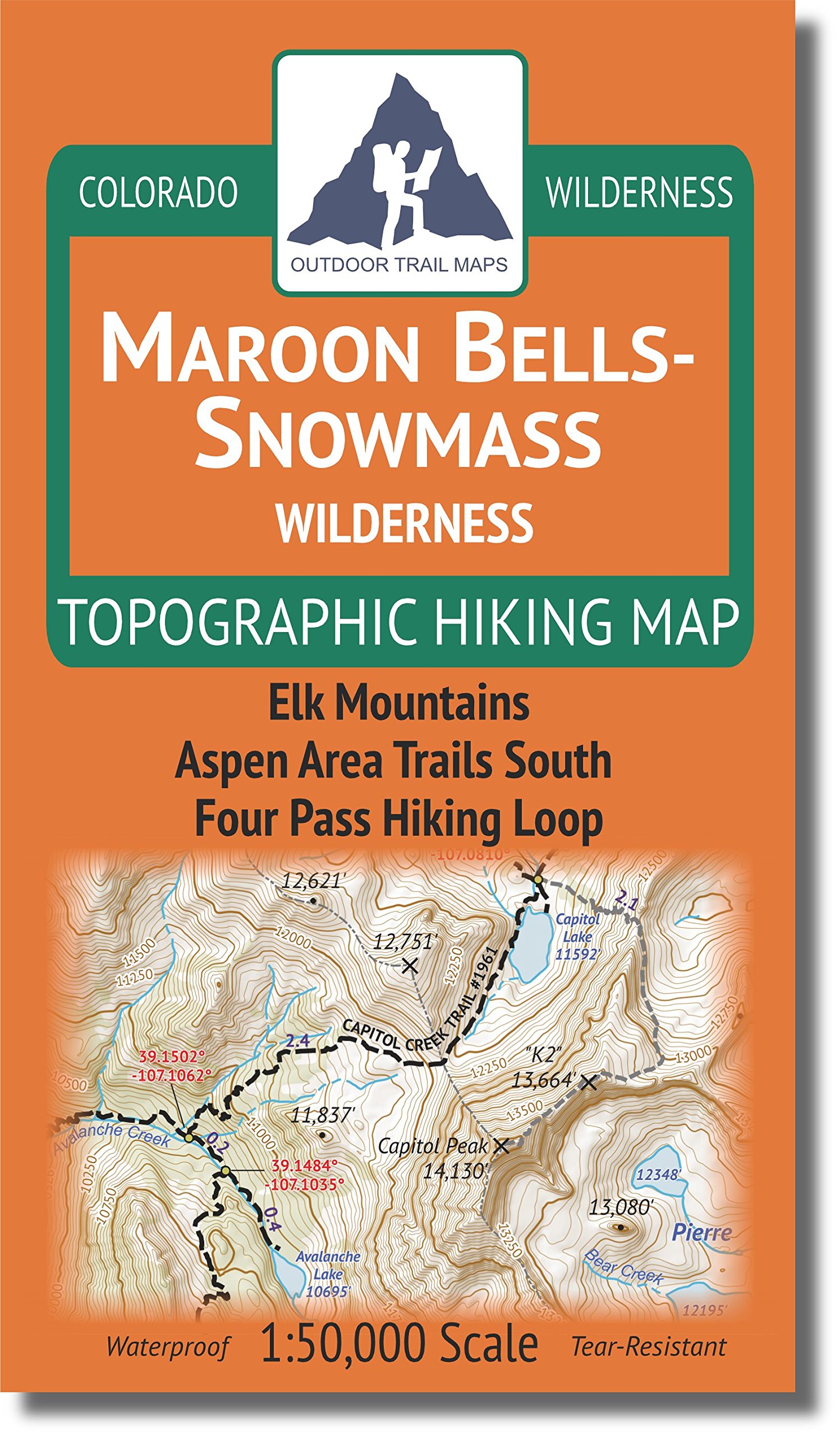
For anyone planning a hiking trip in Colorado’s Maroon Bells-Snowmass Wilderness, this map could be a valuable addition to our gear.
- Compact and pocket-sized for easy carrying
- Waterproof and tear-resistant material
- Accurate trail details with included GPS coordinates
- A few inaccuracies reported by users
- May be less detailed than premium brands
- Some find it challenging to read in low light
This hiking map really shines with its convenient size, fitting comfortably into our pocket while we’re on the trail.
The waterproof and tear-resistant features give us peace of mind, knowing it can withstand tough conditions.
Plus, the GPS coordinates are especially handy for navigation, ensuring we stay on track.
While the map is generally reliable, a small percentage of users mention some inaccuracies, which might require us to double-check details with other sources.
It’s also worth noting that while it has great essential trail information, it may not provide the depth of detail that higher-end maps offer.
In terms of usability, we appreciate the clear layout and segment distances, which really help us gauge how far we’ve hiked.
For those of us who want a practical and effective map for the Maroon Bells-Snowmass area, this option checks many of the boxes we look for when exploring the great outdoors.
Lost Creek Wilderness Map
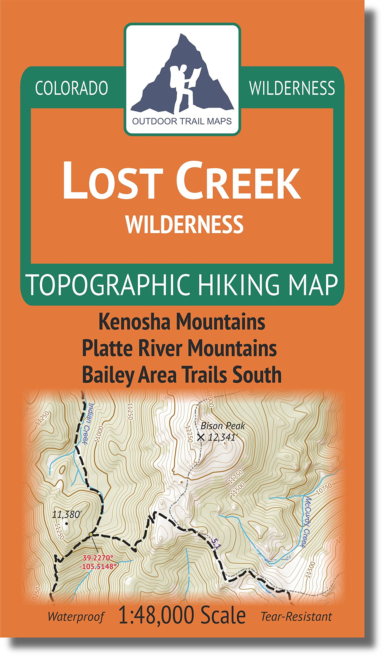
This map is a solid choice for anyone looking to explore the Lost Creek Wilderness with confidence.
- Waterproof and tear-resistant design for durability
- Compact size makes it easy to carry on hikes
- Includes GPS coordinates for easy navigation
- Requires careful handling to ensure it stays in good condition
- Some users may prefer larger maps for more detailed views
- Limited to the Lost Creek area, so not ideal for broader exploration
We appreciate the attention to detail in the design of this topographic map.
The waterproof and tear-resistant materials ensure it can withstand the rigors of the outdoors, making it suitable for all sorts of hiking adventures.
With a scale of 1:48,000, it provides a clear representation of the trails, allowing us to navigate confidently through the wilderness.
Carrying the map is a breeze, thanks to its compact 4″x7″ folded size.
It easily fits in our pockets without taking up too much space.
The incorporation of segment distances and GPS coordinates enhances our hiking experience, as we can plan our routes more efficiently.
This feature is particularly useful when we want to track our progress along the trails.
While the map has superb functionality, it’s worth noting that we should be cautious with its condition.
Although it is designed to resist water, placing it in a waterproof bag for extra protection is advisable.
Additionally, those who prefer wider landscape views may find the size limiting, but for focused exploration in the Lost Creek Wilderness, it fits the bill perfectly.
Flat Tops Wilderness Map

We recommend considering this topographic map for our adventures in Colorado’s Flat Tops Wilderness.
- Waterproof and tear-resistant for rugged use.
- Compact size fits easily in a pocket.
- GPS coordinates provided for easy navigation.
- May not always reflect the most current trail conditions.
- Limited detail on terrain features.
- Requires a bit of experience to interpret all features effectively.
This topographic map from Outdoor Trail Maps offers a rugged solution for exploring Colorado’s diverse landscape.
It covers an impressive 400 miles of hiking trails within the Flat Tops Wilderness, making it a great companion for any hiking enthusiast.
The waterproof and tear-resistant material ensures durability, even when facing the elements.
With its compact folded size of 4â€x7â€, this map is designed for trail use without the hassle of larger maps.
The inclusion of segment distances helps us plan our hikes better, ensuring we can gauge our energy and time effectively.
Furthermore, updated trail routings from 2018 make navigation simpler.
Despite the many benefits, we should be mindful that some trails might not be completely up to date.
Also, while the map is user-friendly, it may not detail every terrain feature, which can be important for less experienced hikers.
Overall, the Flat Tops Wilderness hiking map stands out as a practical tool for our outdoor escapades.
Indian Peaks Topo Map

This compact, waterproof map is a solid choice for those exploring the stunning trails in the James Peak and Indian Peaks wilderness areas of Colorado.
- Waterproof and tear-resistant design ensures durability.
- Compact size makes it easy to carry on hikes.
- Offers detailed trail information, including GPS coordinates.
- Limited to specific regions; may not suit all hikers.
- Smaller size could mean less detail compared to larger maps.
- Some users may prefer digital maps for additional features.
When we’re out on the trails, having the right map can make all the difference.
The Indian Peaks topographic map has been designed to meet many of our hiking needs with its waterproof and tear-resistant features.
This means we can take it into varying weather conditions without worrying about damage.
The compact size of just 4″x7″ allows us to easily stow it in our pockets or backpacks.
This is a real game changer compared to traditional larger maps, which can be cumbersome to handle.
Plus, the included GPS coordinates help us confidently navigate to trailheads and junctions, ensuring we don’t stray off course.
One notable aspect is its focus on the James Peak Wilderness and surrounding areas.
While it excels in detail for those specific regions, hikers venturing beyond these trails might feel limited with this map.
Nonetheless, for hikes in its coverage area, it serves as an excellent resource that is both user-friendly and reliable.
Buying Guide
Choosing the right topographic map for hiking requires some consideration.
We should focus on several key features to ensure a great experience on the trail.
Scale
The scale of a map indicates the level of detail.
A larger scale, like 1:24,000, provides more detailed information, which is ideal for hiking.
Terrain Features
Look for maps that clearly display:
- Elevation changes
- Landmarks
- Water sources
- Trail routes
These features help us navigate effectively and understand the landscape.
Durability
When we’re out hiking, the map should withstand various elements.
Consider maps that are:
- Water-resistant
- Tear-resistant
This quality ensures our map remains usable during our adventures.
User Reviews
Checking user reviews can provide insights into usability.
We can ask questions about clarity or how well the map performs in real conditions.
Availability of Updates
Topographic maps can become outdated.
We should look for sources that regularly update their maps.
This ensures we have the most accurate information possible.
Format
Lastly, consider the format that suits us best.
Options typically include:
- Paper maps
- Digital versions
Digital maps may include GPS features, while paper maps are often more reliable in areas with poor reception.
By keeping these factors in mind, we can select the best topographic map to enhance our hiking experience.
Frequently Asked Questions
We often encounter specific questions about topographic maps that can guide our hiking adventures.
Here, we address some of the most common inquiries to help enhance our map-hiking experience.
These maps provide valuable information about elevation, terrain features, and landmarks, making navigation more efficient.
To pinpoint exact locations, hikers can rely on the best grid reference tools, which help ensure accuracy when plotting routes.
Understanding how to use these tools effectively can significantly improve safety and confidence during outdoor excursions.
What’s the best website to find topographic maps for trails?
For trail-specific topographic maps, we find that sites like CalTopo and Gaia GPS offer detailed resources.
They allow us to customize maps and download them for offline use, which is essential when hiking in remote areas.
Which topographic map scale is ideal for detailed hiking navigation?
A scale of 1:24,000 is generally ideal for detailed hiking navigation.
This scale provides a good balance of detail and coverage, allowing us to see trails, contours, and other important features clearly.
Are there any reliable free sources for topographic hiking maps?
Yes, we can access reliable free sources for topographic hiking maps.
The USGS offers a vast library of maps that we can view and print for free, along with various state park websites that often have downloadable maps.
How do Tom Harrison maps compare to USGS topo maps for hiking?
Tom Harrison maps are known for their clarity and trail-specific details, making them a popular choice among hikers.
They focus on recreational areas and often include information on local trails, which can be more extensive than some USGS maps.
Can you get accurate topographic maps from AllTrails for off-trail hiking?
While AllTrails is great for trail maps, it may not always provide the best data for off-trail hiking.
We should be cautious knowing that the accuracy of off-trail navigation can vary and it’s wise to cross-reference with more detailed topographic maps.
What features should I look for in a map when planning a backpacking trip?
When planning a backpacking trip, look for elevation contours, water sources, and trail conditions.
Information regarding terrain types and potential hazards can be valuable in your planning process for safety and navigation.